nomadic ADVENTURES

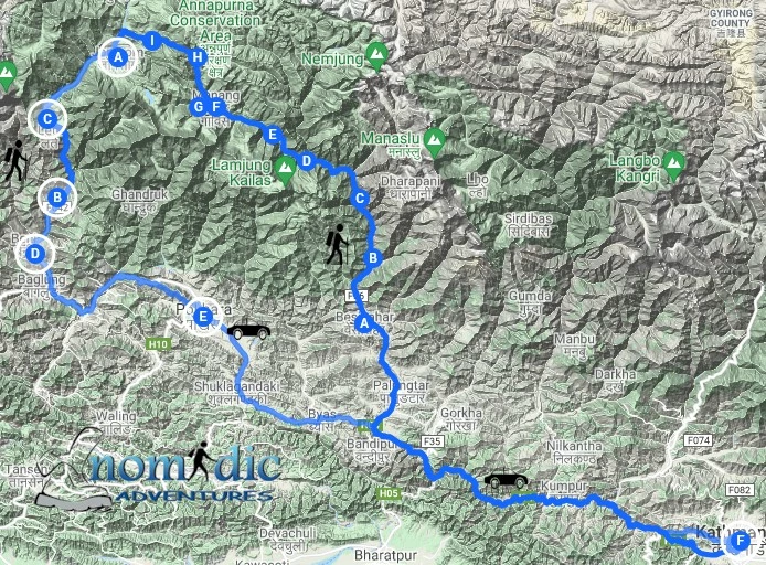
ANNAPURNA CIRCUIT itinerary

Day-1: Arrive Kathmandu

Arrival and transfer to Hotel.

Day-2: Guided Sightseeing

Guided sightseeing around Kathmandu valley.

Day-3: Kathmandu to Pokhara

Drive from Kathmandu to Pokhara. Pokhara is the gateway to the Annapurna region. Hotel Overnight.

Day 04:  Drive to Besisahar (923m) and trekking to Bulbule.

From Kathmandu, we start early for our drive to Besisahar. We travel by bus arranged by us. The road up to Besisahar is of fair quality. Once we have reached Besisahar we walk about another two hours to Bulebule close to Marysangdi river. It’s an easy trek to Bulbule after the long bus journey. Once we reach there, we freshen up and spend the night there.

Day 05:  Trek to Chamje (1410m)

On the first day of the trek, we cross various suspension bridges, waterfalls and continue past rice paddies and forests. Once we reach the cliff in Jagat, we can view the Marsyangdi Khola below and rocky hills all around. The beehives at the top of the cliffs are an attraction for today. In a short while we will reach Chamje where we spend the night.

Day 06:  Trek to Bagarchhap (2160m)

As we move past narrow and steep valleys, through rhododendron, pine and bamboo forests, in the rocky folds of a mountain, we come across a bridge that takes us to a quick ascent and finally atop a climb to reveal a widening valley. After reaching the village of Tal, we have to move across barley, wheat and potato farms for a while before we reach Dharapani. From there we turn west through the fir and pine forests to reach Bagarchhap.

Day 07:  Trek to Chame (2710m)

From Bagarchhap we start ahead to reach a Danaque village and then a steep climb to reach a Tamang village with exquisite views of Manaslu, Lamjung , Annapurna and other mountain beauties. As we trek through a Tibetan village that acts as a transition between the lowlands and high hills, we follow a gradual flat path to Thanchowk, Kolo and finally to Chame.

Day 08:  Trek to Pisang (3240m)

We first pass through the older part of Chame, climb up to Telekhu and continue on a long, leveled trail through forests underway to Brathang. The trails rounds a bend and once we continue ahead we need to cross back to the south bank of Marsyangdi River on a suspension bridge. Then the trail takes us on a gentle ascent over a pine forested ridge and then levels again as we move from the upper part of Manang valley to Pisang.

Day 09:  Trek to Manang (3540m)

The town of Pisang is the start of the upper region of the Manang district. On this day, the trek climbs to Braga, a Tibetan styled village. The houses here are stacked upon each other forming verandas with each others rooftops. The main attraction is the Gompa, the largest in the district, with a vast array of statues in display and perched on a high crag with the view of the entire village. After a while we reach Manang, where we freshen up and spend the night.

Day 10:  Acclimatisation in Manang

As we are reaching higher altitudes, we need to acclimatize to avoid the risk of altitude sickness. Manang is the perfect spot with its beautiful natural setting and a hike up to Khangsar in the afternoon for a short detour.

Day 11:  Trek to Yak Kharka (4120m)

Now that we are rested, we feel rejuvenated to continue on our trek. As we move past the tall trees towards the alpine grass and junipers, we reach meadows where a few horses and a number of yaks are grazing around. The serene environment with meadows and steep slopes of Yak Kharka is the perfect place for us to spend the night. We can also choose to walk for an hour to reach Letdar and spend the night there

Day 12:  Trek to Thorung Phedi (4.560m)

Trekking to Letdar helps getting acclimatized to the increasing altitude as we ascend along the east bank of Jarang Khola. In some time we reach a meadow surrounded by vertical cliffs, the Thorung Phedi. Sighting of blue sheep and snow leopards have been reported a few times in the area, whereas Lammergeyers and griffons are quite common. We spend the night here.

Day 13:  Over Thorung La (5.416m) to Muktinath (3.802m):  8 hours

Today we will hike for about 7-8 hours. The trail is comparatively easier having been trodden for years, but could get difficult with strong winds in the upper regions. The trail is believed to have been used for hundreds of years to take sheep and yaks in and out of Manang along with other trading goods. We reach Thorung Phedi in about 6 hours. After we reach Thorung la pass, our hike will be rewarded with beautiful views of Annapurna, Gangapurna and a heavily glaciated peak of Khatungkang. When are a done with a descent of about 1600m, we view the glorious Dhaulagiri standing in the distance. After a while, the trail becomes less steep and enters grassy fields and meadows to finally reach Muktinath. In Hindu religion, Muktinath refers to a place of nirvana which houses a temple and a number of monasteries, making it a holy site for Hindus and Buddhists alike. The main attractions of the site are the Jwalamai temple with a spring and an eternal flame as well as the 108 water spouts that pour holy water. These are visited by thousands of pilgrims every year.

Day 14:  Trek to Jomsom (2750m) via Kagbeni.

From Muktinath, we follow a trail part of the Jomsom trek where we descend through meadows, streams and fruit trees to finally reach Kagbeni. We look around the old village and then moving downwards. From Kagbeni we reach Jomson, Kali Gandaki valley.

Day 15:  Drive to Tatopani (1190m):  Hot Water Springs

The road from Marpha to Kalopani goes via a new trail past Chokhopani village which is a traditional Thakali village. The panoramic views of the Himalayas include Nilgiri, Dhaulagiri, Tukuche, Annapurna and many other snow-capped peaks. From here we cross a river and a newly constructed road that will make us finally reach Kalopani.

Day 16:  Trek to Ghorepani (2750m)

Today we move from Tatopani through villages of midland Nepal with terraced fields and inclined farmlands. As we hike and ascend we move past rhododendron, magnolia and other vegetation of the area. We finally reach Ghorepani as we witness the beautiful mountains under the evening sky. We rest in Ghorepani to make an early start pushing for Poonhill in the morning.

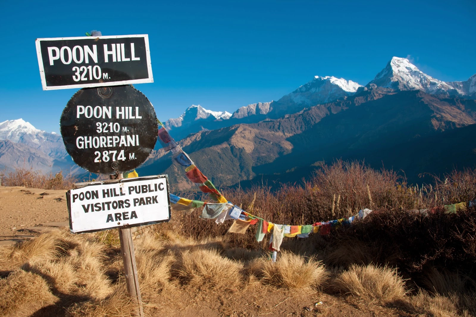
Day 17:  Ghorepani:  Poonhill:  Nayapul. Drive to Pokhara:  7 hours

We have an early morning ascent of Poonhill for the sunrise. This has to be the highlight of the trek as we make our trip to the vantage point early in the morning with sunrise. Once you see the snow-capped peaks highlighted in the changing golden rays of the sunrise, it will be one of the most unforgettable moments of your life. The peaks in the scenery include the Annapurna range and Dhaulagiri. Known as a photographer’s paradise, we can spend some time here taking breathtaking pictures of the spellbinding surroundings, capturing the spectacular moments in a frame. We then descend to Ghorepani for breakfast and then trek for 5 hours down to Nayapul. The first part of the trek down until Tikhedhunga is quite steep down hill. From there we move past terraced fields for a few hours to reach Nayapul. From there a short drive will finally take us to Pokhara.

Day 18:  Return drive to Kathmandu and transfer to hotel:  7 hours

After enjoying beautiful Pokhara and its natural and cultural beauty, we begin our drive towards Kathmandu. After about 6-7 hours, we finally reach Kathmandu. We can either rest or go discover the tourist attractions in the capital city.

Day 19: Depart Kathmandu


End of services


SUBSCRIBE TO OUR NEWSLETTER

bELOW ARE SOME OF THE QUESTIONS WE ARE FREQUENTLY  ASKED about EVEREST BASE CAMP

What is the height of Annapurna circuit?

The highest elevation you will reach is 5,400 m on the Thorung La.

How difficult/challenging is this trek?

In general if you are happy walking for 5 to 6 hrs a day with a light day pack then you should be fine so long as you are fit in advance. Trekkers should be comfortable with occasional rough terrain, but expect long steep climbs. Some days could include ascents and descents of 500 metres or more. Most walking is done in the morning and afternoons are for relaxing. One thing you can’t train for though  is altitude and that can prevent people reaching base camp where there is 50% less oxygen compared to sea level. The secret is to acclimatise well and to do so you need to take a slow pace, a good itinerary, ascend to altitude slowly, rest, eat good food, sleep well and drink plenty of fluid.

Overall the days are manageable covering 10-15kms, with plenty of rest, long lunch breaks and a few rest days in between. Some days on your trek will involve 16 hours at high altitude starting at 4am when you cross the pass. 

The circuit is very tough at times, and the high altitude and unpredictable weather of the Annapurna mountain range can make crossing the Thorong La Pass a long and difficult task. It’s a trek anyone with reasonable fitness can tackle and hope to complete. What makes it hard is not only the steep climbs and long distances, but also the altitude.

How long is the Annapurna Circuit?

The total length of the route varies between 160–230 km, depending on where motor transportation is used and where the trek is ended. This trek crosses two different river valleys and encircles the Annapurna Massif.

What are the tea houses like?

Tea houses are accommodations along trekking routes in Nepal that offer basic lodging and meals. The rooms are all generally basic.  The higher elevation rooms do not have toilets, and some facilities only have squat toilets. Lodges at lower levels may have attached private bathrooms.  There is no heating and electricity is often solar and on only for a few hours in the evening. Rooms have a bed, pillow and a thick blanket a small light. Guesthouses and teahouses are dotted along the whole trek, starting from Besisahar all the way to Jomsom. 

To the west, the Annapurna region is protected in a vast conservation area managed by the National Trust for Nature Conservation (NTNC). Tea houses in the Annapurna are monitored by the NTNC and must meet specific requirements including fixed pricing, standard menus, and limits on how many tea houses can be built along specific routes.

Which is the best season to trekking in Annapurna?

The best time to visit the Annapurna region is either side of the late May to mid-September monsoon season. Late September to November and February to May are the main trekking months with fairly stable conditions, good visibility and temperatures at about -6°C at higher altitudes, though it can go lower.


The Annapurna Circuit sits in a rain shadow, which allows for trekking during monsoon as well.

Can I charge my camera batteries and mobile phone during the trek?

Yes, you can charge your batteries and mobile phones in every place by paying extra at the rooms do not have charging facilities. The price of charging may vary in different places. It is wise to bring your power bank which you can charge in Kathmandu and use it in the higher area as charging batteries in the higher area is quite costly.

What are the meals like on the trek?

You can choose the food from the menu and it depends on the places. You can also choose local dishes and continental/Chinese dishes. However, food is cooked by the basic local lodges so the variety and flavour differs from one place to the next.

How will the altitude affect me on Annapurna trek?

This is a really difficult one to answer directly - "how will I cope with the altitude". To be honest, this is an ' unknown' factor as no-one can predict how your body will cope at altitude. People who have been to altitude many times in the past without problems, may on one climb suddenly develop problems. There are many factors that play a role. The only way to help combat this, is to take all of the necessary precautions, and walk slowly. Regardless it is better to go in an anti clockwise direction.                  

Where can I get Where can I get climbing Insurance for Annapurna Circuit?

If you are going hiking or climbing or trekking then you need extra cover for your activities. Hiking and Climbing have become popular for many adventure seekers looking to add a climb up Kilimanjaro or a trek to Annapurna or even Island Peak to their list of amazing adventures. But any climb to high altitude carries with it a number of risks and having the correct and good trekking insurance is an absolute must. We recommend two different groups depending on which country you reside in. For further details, click on the icon


Which is better, Annapurna Circuit or Annapurna Base Camp?

The two trips are very different.  The Annapurna Circuit trek is a longer more challenging trek with mountain passes and higher altitudes.  The Circuit trek goes around the northern side of the Annapurna Mountain Range and you do not actually go to Annapurna Base Camp when you are on the Circuit trek.  Also, you reach an altitude of 5,420m/ 17,782 feet on the Circuit trek, and on the Base Camp trek, the highest point reached is at 4,131m/ 13,553 feet. 


Both the Annapurna Circuit and the Annapurna Base Camp Trek are quite exciting in their own way. If your goal is to get the best views of the Annapurna Region, then you can choose either one. On either trek, the Annapurna Massif will be center of attention.

Is it better to  go clockwise or anticlockwise?

Almost all trekkers do the Annapurna Circuit Trek in an anti-clockwise direction. This way the altitude gain is less and people are less prone to the effects of altitude sickness. The Thorung La Pass, at 5416 meters (17769 feet) is the highest point of the Annapurna Circuit Trek and is, together with the various peaks you will see on the route, an absolute highlight of the trek.

read some of our blog posts on ANNAPURNA TREKS

A Himalayan Sandwich - Best times for the Annapurna Circuit

It is one of those treks that give you a little bit of everything on offer in Nepal, but don’t be misguided into thinking it is easy. Tackling high passes like the Thorung La at 5416m is no easy feat and given the unpredictable weather, heading out well prepared is essential.... Continue reading 

KEEPING YOUR CELL PHONE ALIVE ON at altitude

Well the answer is quite simple – snuggle up with all of your batteries at night or as soon as the temperatures drop. Packing a spars pair of warm thermal and mohair socks will go a long way to creating a nice warm package for all of your batteries. Continue reading 

training for High Altitude?

Altitude is much like elevation only it refers to the distance measured above a specific planetary point, and in most places, this is the distance above sea level. So if we live at the sea, how do we train for high altitude? Getting technical about O2 and altitude At sea-level, the concentration of oxygen in … Continue reading 

hiking vs trekking

The terms seem to be used interchangeably on many websites and travel books. It becomes even more confusing when some companies sell their boots as 'trekking boots' and then proceed to state that they can be used on long hikes. And when is a walk a trek and when is it a hike? It becomes … Continue reading 

these boots are made for walking

Kilimanjaro, the Inca Trail, Everest Base camp or a simple short hike on local trails. We all dream of these amazing places and for some of us, turning those dreams into a reality is like a brand new lease on life.

Continue reading